
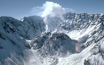
Mount Mazama is a destroyed stratovolcano in the Oregon part of the Cascade Volcanic Belt and the Cascade Range. The volcano's collapsed caldera holds Crater Lake, and the entire mountain is located in Crater Lake National Park.
Mazama is most famous for a catastrophic volcanic eruption that occurred around 5,677 (± 150) BC. The eruption, estimated to have been 42 times more powerful than Mount St. Helens' 1980 blast, reduced Mazama's approximate 11,000 foot (c.3,350 m) height by around half a mile (about 1 km) when much of the volcano fell into the volcano's partially emptied neck and magma chamber. At 8,159 feet (2,487 m), Hillman Peak is now the highest point on the rim.
History
For a summary see: Geology of Crater Lake
Geology
Mazama started to grow around 400,000 years ago in the Pleistocene, mainly from lava flows interbeded with some pyroclastic material. These early flows averaged 20 to 30 feet (6 to 9 m) thick and appear to have been emplaced over a few years to a few centuries. Several shield volcanoes were created by these flows and numerous cinder cones grew in the immediate area (these may or may not be parasitic vents). More explosive eruptions started around 75,000 years ago and built a westward-trending line of composite cones.
Cone building eruptions lasted until around 50,000 years ago when andesite lava flowed down Mazama's north and southwest slopes. Relatively few of the cone building eruptions issued from the same vent, resulting in a highly complex approximately 11,000 foot (c.3,350 m) structure made of overlapping composite cones and shield volcanoes. Consequently, Mazama's base was broader and its side not as steep as today's Mount Shasta or Mount Rainier.
 Growth phase
After its cone building phase, Mazama lavas became increasingly silica-rich and viscous - two conditions that tend to trap explosive gases. The first major eruption in this new cycle of Mazama's life occurred about 10,000 years later, when dacite flows high on the volcano's southwest face formed a series of domes. These structures were subsequently destroyed by either collapse or steam explosions (see phreatic eruption). Either way, their destruction created large landslides that left deposits at the head of Munsen Valley and as far away as Devils Backbone.
Mazama's next major eruptive period occurred between 25,000 and 30,000 years ago and extruded rhyodacite lava (which has a higher silica content than dacite). These thick, slow moving, pasty flows erupted from a vent on Mazama's northeast flank and solidified to form 600 foot (180 m) high Redcloud Cliff (later cut in two by caldera subsidence) and a dome above what today is Steel Bay.
The volcano then went dormant for roughly the next 20,000 years, while successive ice age glaciers (probably as thick as 1,000 feet (300 m) in troughs) cut large valleys into the mountain's sides. One of the largest glaciers flowed down Munson Valley near the present location of park headquarters, down Annie Creek Valley, and perhaps as far as Fort Klamath. When the last ice age ended 12,000 years ago, those glaciers retreated upslope past the elevation of the current caldera's rim. While Mazama slept, its magma chamber was going through some differentiation, with lighter, more gas- and silica-rich rocks collecting closer to the surface.
Silica enrichment
Around 5000 BC Mazama awoke from its slumber with explosive rhyodacite eruptions on the northern part of the main summit where Llao Rock now resides. Great quantities of pumice and ash were ejected as a large crater was excavated by the explosions. The tephra was carried by prevailing winds to the east and southeast. Associated with this was a pyroclastic flow that was 1.25 miles (2 km) wide, 1,200 feet (about 360 m) thick at its deepest point, and contained 0.25 mi³ (1 km³) of material (later, caldera forming subsidence cut the partially filled crater in two, exposing it in cross section - today this is called Llao Rock).
One to two hundred years later (based on radiocarbon dating) the last major eruption before the caldera was formed, the Cleetwood flow, occurred. This rhyodacite lava flow erupted from a vent near what is now the north caldera rim. The Cleetwood flow was still fluid when the caldera was formed, so it must have erupted just weeks to months beforehand. When Mazama later collapsed into itself, some of the Cleetwood lava backflowed into the caldera.
Mazama's final act started with a large eruption that sent a mile (1.6 km) wide column of hot tephra 5 to 10 miles (8 to 16 km) into the sky at almost twice the speed of sound. The column collapsed in a series of pyroclastic flows that covered much of the area between and downslope of Llao Rock and Redcloud Cliff. This flow, the first of many, was so hot that it solidified as a welded tuff called the Windglass Welded Tuff. Flow after flow followed in rapid succession, stressing the ability of Mazama's magma chamber to recharge. The mountain started to sag under its own weight. Concentric ring fractures started to form around the volcano, creating convenient conduits for additional volcanic vents.
The eruption entered its final and most destructive cycle with very large and erosive pyroclastic flows erupting from ring fractures all around the volcano. These flows moved out in all directions from Mazama, following river valleys and in some cases not coming to rest for 40 miles (65 km). As the eruptions were occurring Mazama was imploding.
The collapse and the erosive ring eruptions fed each other - the sinking volcano pushed magma upward and the erupting material both lubricated the downward subsidence and eroded the sides, making it easier for much of Mazama to sink into the earth. Also, the sudden and dramatic reduction in overpressure on the remaining gas charged molten rock in the magma chamber caused it to react by immediately exploding into a super-heated mix of liberated gases and various grades of pulverized and often frothy lava known as a pyroclastic flow. The force of the explosion pulverized previously solidified rock that happened to be nearby or that recently fell into the caldera from the collapse.
Half of 70,000 year old Hillman Peak was blown away, exposing the cone in cross section. Many glacier-cut canyons were beheaded and now stand as notches in the caldera rim. Notable among these are Kerr Notch, Munson Valley, and Sun Notch.
The last pyroclastic flow of this stage was andestic scoria, indicating that Mazama was drawing on material deep from within its magma chamber. This layer of material now forms a dark band in ash layers associated with this eruption cycle (it also created the Pumice Desert). A last few dying gasps in the form of a series of relatively weak explosions then deposited a well-bedded layer of pumice lapilli and crystal-rich ash up to 50 feet (15 m) thick on the newly formed caldera rim.
In the end an estimated 11 to 14 mi³ (46 to 58 km³) of magma escaped from Mazama's magma chamber during this eruptive cycle as approximately 25 mi³ (104 km³) of tephra (magma is compact due to high pressure surrounding it). The magma was replaced by about the same volume of material when most of Mazama fell into its caldera.
Explosive phase
Hundreds of square kilometres of the surrounding countryside were destroyed by material ejected from the collapse and associated eruptions. One pyroclastic flow traveled 40 miles (64 km) from Mazama down Rogue River Valley while another moved north in-between Mount Bailey and Mount Thielsen, moving over Diamond Lake (it finally came to rest in North Umpqua River valley). Winds carried tephra (ash and pumice) from Mazama northeast, where it covered over 500,000 square miles including nearly all of Oregon, Washington, northern California, Idaho, western Montana, and parts of Nevada, Wyoming, Alberta, British Columbia, and Saskatchewan.
Geologists know the exact chemical composition of this tephra (which they call Mazama ash) and both geologists and archeologists use the distinctive layer it formed in relative dating. As with all tephra layers, Mazama ash is thickest near its source (20 feet (6 m)) and becomes thinner with increasing distance from its source (70 miles, 110 km northwest it is 1 foot (0.3 m) thick).
Pyroclastic flow material near Mazama remained extremely hot for months, and in some places they were more than 250 feet (76 m) deep. Hot gases escaping from the cooling deposits tended to follow vertical channels and emerged at the surface as fumaroles. Over time these gases cemented the channels, which are now exposed as very tall vertical columns and spires of tuff (good examples are along the upper walls of Sand Creek Canyon and Annie Canyon).
Post-collapse phase
Assuming no large eruptions destroy it first, Crater Lake will eventually be destroyed when erosion breaches the caldera rim and the lake escapes as a massive flood. Future eruptions will probably continue to follow the post-collapse pattern of being confined to the caldera. Additional cinder cones and lava flows will likely issue from fissures on the lakebed; some will be totally under water, while others may reach the surface to create new islands and peninsulas. Lava flows may build-up over time, reducing the lake's depth and may eventually divide it into more than one body of water (this happened to Newberry Caldera).
Less likely would be the resumption of cone-building activity and the creation of a coalescing chain of small stratovolcanoes. These could, in time, merge to reform Mazama to an approximation of its former glory. Even less likely would be a repeat of the cataclysmic eruption that formed the caldera (however, recent Mazama lavas do show an increase in silica content, so this still is a possibility).
See also
No comments:
Post a Comment